
Tolar astronomical observatory
Satellite imagery: Esri, Maxar, Earthstar Geographics
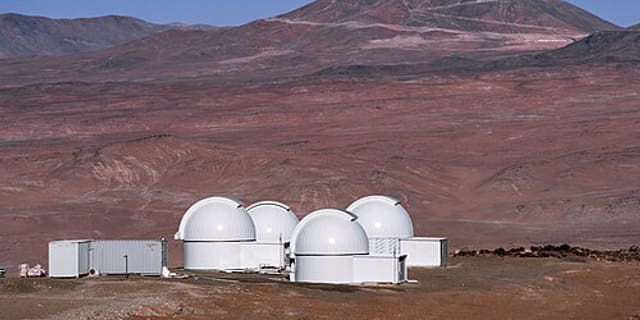
Tolar Astronomical Observatory perches on the remote Cerro Macón highlands near Tolar Grande in Salta Province, Argentina, at an elevation that makes it the country's highest-altitude observatory.
About Tolar Astronomical Observatory
The site operates as TOROS — the Transient Optical Robotic Observatory of the South — a collaborative project run by the University of Texas at Brownsville, the Universidad Nacional de Córdoba, Caltech, and Texas A&M University. Its purpose is to serve as an optical follow-up instrument for gravitational wave detections made by Advanced LIGO and Advanced Virgo.
Telescopes & research
TOROS scans the sky for the fleeting optical counterparts of gravitational wave events, a young but fast-growing field of astronomy that pairs observatories like this one with the LIGO and Virgo detector networks. The station's remote, high-altitude Puna/Altiplano location gives it an unusually high probability of clear skies and very low light pollution, with conditions that have been compared to the harshness of Antarctica.
Location & getting there
Sitting at roughly 4,665 metres above sea level in the Cerro Macón area of Salta Province, Argentina (about -24.59°S, -67.40°W), Tolar is a genuinely remote outpost, roughly six hours' travel from the city of Salta.
Visiting Tolar Astronomical Observatory
Given its extreme elevation and role as a robotic research facility, this is not a casual tourist stop. Anyone interested in the site or the surrounding Puna region should check with local Salta tourism resources or the operating universities before planning a visit.
See your named star from here
While TOROS is purpose-built for chasing transient gravitational-wave counterparts, the same fundamental idea applies everywhere: any telescope can be aimed at a fixed set of sky coordinates, including the right ascension and declination of a named star. Discover our star-naming packages or browse the star catalogue.
Opening hours and public-visit programs vary by season. Check Google Maps for current times before you travel.
Institutional and reference sources used to verify this guide.
Satellite imagery: Esri, Maxar, Earthstar Geographics

 302 km
 304 km
 304 km
 591 km