
Bruce Peninsula National Park

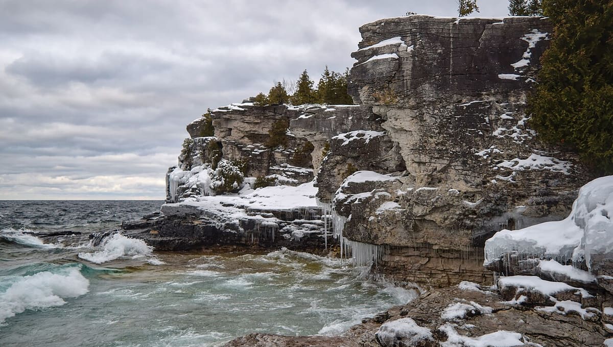
Image: The Cosmonaut · CC BY-SA 2.5 ca · Wikimedia Commons
Bruce Peninsula National Park occupies the tip of the Bruce Peninsula in Ontario, Canada, wedged between Lake Huron and Georgian Bay about 200 kilometres northwest of Toronto. Covering roughly 154 square kilometres of Niagara Escarpment shoreline and forest, it was designated a Dark-Sky Preserve by the Royal Astronomical Society of Canada in 2009, four years after the Municipality of Northern Bruce Peninsula proclaimed itself a Dark Sky Community.
Why Bruce Peninsula National Park is a top stargazing spot
The park holds Bortle Class 2-3 skies, among the darkest available in southern Ontario, and a sky quality meter reading of 21.5 magnitudes per square arcsecond was recorded at Cyprus Lake in 2009, confirming just how little artificial light reaches this stretch of shoreline. With minimal light pollution drifting in from the surrounding region, the Milky Way stands out clearly on clear nights, and the park is also known for some of the best northern lights displays in southern Ontario when aurora activity picks up; the aurora is visible here roughly five to twenty five times a year, more often in winter, though a vivid, easily photographed display remains rare, showing up on less than one percent of nights.
What you can see
Alongside the Milky Way and the aurora, visitors can pick out star clusters such as the Pleiades, watch for meteor showers, and occasionally spot comets. Park staff and volunteers with the Royal Astronomical Society of Canada run outreach programs, including presentations, night walks, and telescope viewing, and the Bayside Astronomy program keeps a rotating weekly schedule through the summer: Fridays and Saturdays at the Lion's Head marina from Canada Day through Labour Day, then Sundays at Singing Sands, Mondays at Miller's Family Camp, and Wednesdays at Summer House Park.
Visiting Bruce Peninsula National Park at night
Singing Sands is worth seeking out specifically for night viewing: it's a coastal site with no artificial lighting and a low, open horizon over Lake Huron. Cyprus Lake is the park's main visitor facility area, with a drop-in interpreter station at the Head of Trails and two campgrounds, Cyprus Lake Campground and Tamarack Campground, both close to Cyprus Lake Road, if you'd rather stay overnight than drive back in the dark. The park's hiking trails range from easy to expert and connect to the wider Bruce Trail, so there's plenty to explore before the sky darkens. Check the park's schedule for RASC talks and Bayside Astronomy sessions, and bring a red flashlight to protect your night vision once stargazing begins.
Best time to go
The Milky Way's bright core is best seen from Bruce Peninsula from around March through September, arcing low over Georgian Bay after dark. Winter nights trade the galactic core for the bright winter constellations, Orion, Taurus, and the Pleiades among them, and are also, somewhat counterintuitively, the best season for aurora activity here. The Perseid meteor shower peaks in mid-August and the Geminids in mid-December, both good reasons to time a visit around a new Moon; whatever the season, plan for 20 to 30 minutes of dark adaptation before the sky reveals its faintest detail, and keep white light to a minimum.
Getting there
The park sits at the northern tip of the Bruce Peninsula, roughly 200 kilometres, about a three hour drive, northwest of Toronto via Highway 6, with Tobermory as the nearest town at the peninsula's tip.
See your named star from here
With some of the darkest skies in southern Ontario, Bruce Peninsula National Park is a solid place to actually go looking for a star named in your honour. Bring your certificate's coordinates and a stargazing app to one of the park's night walks or a Bayside Astronomy session, find your star in the catalogue, and check our observatories list for other dark-sky sites nearby.
Conditions and access vary by season. Check the official website and Google Maps before you travel, and aim for a clear night near the new Moon for the darkest sky.
Satellite imagery: Esri, Maxar, Earthstar Geographics

 141 kmPreserve
 153 kmPreserve
 169 kmPreserve
 254 kmDark Sky Park